Primary sources are an immensely important part of digital history, as they allow us to analyze and learn about the past from first hand sources and materials. Everything from photos to newspaper articles and written accounts can aid us in developing a better understanding of past events.
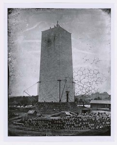
This photograph, taken circa 1876, depicts the construction of the foundation for the Washington Monument in Washington DC. The picture was created by the Federal Works Agency Public Buildings Administration, and is currently included in the Still Picture Records section of the National Archives at College Park. By examining the image, it is evident that the image was taken before the break in construction which occurred from 1854 to 1877, as there are scaffolding and raw materials all around the unfinished monument, as well as men who seem to be working on the top of it. Some greenery and a few buildings are visible in the background, which gives a look into the landscape of DC at the time, which was not nearly as developed and held many more trees than it does now. There is also water visible in the background, though we aren’t told which side of the monument we are shown, so it is difficult to tell if this is the river or an canal that existed at the time. This image gives insight into the layout of DC in the late 1800s, as well as a visual understanding of the construction process of the famed Washington Monument.
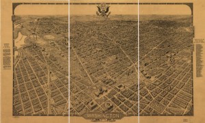
This map, published by the Columbia Planograph Company around 1922, depicts a birds eye view of Washington DC. It is not drawn to scale, and north is meant to be in the top right corner. The capital building can be seen in the center of the map, with the national mall stretching before it and many other, unidentified buildings surrounding it. Despite not being to scale, the map does show the size of DC at the time, as well as the number of buildings and the division of street blocks. Along the side of the map, it does identify important buildings and places of interest, making this map useful for gaining a sense of the size of the city and it’s buildings and monuments. It would also be useful in identifying many of the differences between the city’s current look, and the way it looked years ago.
These sources are essential to understanding Washington DC as it used to exist, as well as its development into the city we now know. The photograph of the Washington Monument was more difficult to analyze than the map, because less space is shown and less visual information is provided, but both show important insight in their own way.


