Make a Map

Screen Shot 2014-04-07 at 2.50.48 PM


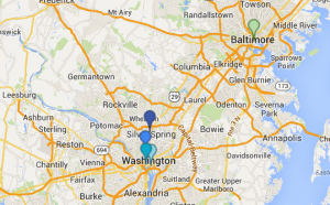
One vital step in understanding history is understanding maps. Maps, new and old, electronic or hand-drawn, all helps to serve as a visual aid for understanding historical landmarks and events, and how they may interrelate to each other. I create the above map using google’s “maps enginge”, in order to display important locations in the understanding of the Smithsonian National Zoo, and it’s role within the society of Washington, D.C. I, of course, marked the Zoo itself, as well as Association of Zoos and Aquarium’s Headquarters, the Smithsonian Institution Building, and the National Academy of Sciences on the first layer, as they all play an integral role in running, maintaining, and aiding the zoo in it’s public operations and the care of its animals. On the second layer, I marked the National Aquarium, as it falls under the same category as the zoo in terms of it’s role as a scientific landmark and a public exhibit for education and entertainment.

I didn’t have much difficulty while actually making the map, other than locating some of the latitude and longitude points and verifying that I had them correct. The maps engine was simplistic enough to use with ease, but still allowed for customization and personal preferences to be utilized. The map itself is useful in understanding how all of these organizations and buildings work together to make locations like the Zoo and the Aquarium run and benefit our city educationally and socially. Seeing the areas in relation to each other really gives an idea of their importance, due to their central location within the city and their proximity to each other.

Creating a map is an extremely helpful and important part of understanding historical situations, and is definitely something I’ll be utilizing in my future research.

The National Zoo!

After last week’s research on a few broader topics, I really feel that I’m drawn to the National Zoo! I’ve always enjoyed going myself, and I’ve never really thought about all the history and development that went into it until now. I’d like to delve further into the development of the zoo concept, and how the decision was made to open one in our nation’s capital, as well as into the zoo’s initial planning and development. I’ve already learned that it was originally on the National Mall! They also didn’t hire their first, full-time veterinarian until 1950. What were the first animals at the zoo? How were they chosen and transported to Washington DC? What was the initial reaction of the people to the creation of the zoo? To look further into this, i plan to draft an array of questions I’d like to see answered, and do my research to find as much history as I can. I’ll search for news articles from the opening, any reviews that may exist, photographs of the original zoo to compare to more modern images, and the legislation which helped to build it. I think researching this topic will be very fulfilling to myself, personally, and will make for an interesting and insightful look into a different part of Washington DC.

Final Project Topic Ideas

Washington DC is full of rich and vibrant history around every corner, so much so that there are millions of topics which can be analyzed and researched to give us a greater understanding of this great city and it’s development. I personally find myself drawn to a few topics in particular, all of which I feel are important to the understanding of the city as a whole and as it developed, and which are important to me personally.
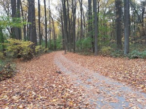
sligo creek parkway


I’ve always found myself interested in the roll of parks and similar parkways within a city environment. These places of tranquility amidst the hustle and bustle of the urban city have always captivated me, and I continually desire to see more of them in some of our most busy areas, where trees are more often cut down than planted. In places like DC, people don’t often look past the grand monuments and historic buildings, completely missing the beauty that can be founds along the river and into the greenery surrounding the area. For this reason, I feel the development of parks and parkways in and around Washington DC might be a great topic to explore. The suburban city developed alongside the natural elements which surround it, and neither would be as substantial or beautiful without the other. Parks offer a sense of solace and interaction between citizens outside of their daily lives, and are essential to the social constructs of DC, as well as other major cities. I would love to explore these places, such as the Sligo Creek Parkway near DC, and analyze the process of conception to development, from how they’re designed and planned to how they’re created and utilized by all different people within the city.

panda

The Smithsonian National Zoo is a major attraction in Washington DC, and one that brings together the social, ecological, and even political nature of our city into one, family-friendly location. The creation of zoos played an essential roll in changing the way early people viewed animals; where they were primarily accustomed to hunting and killing native animals for food and trophy, they were suddenly able to view beautiful and abnormal creatures in their own habitats and learn about them safely. The zoo brought together a desire for cultural and social interaction within the city and the increase in awareness and knowledge about the animal world in a vast multitude of different countries by creating a place where people could socialize while being educated on the importance of different animal species to our planet. the zoo has even been used as a political segue, helping us to form relations with other countries and to show our respect and love for their native animals (for example, China and the Pandas they gifted us, which are now a major attraction). By studying the development and usage of the Smithsonian National Zoo, I can look deeper into the social constructs of the city, as well as into the importance of communal gathering, nature, and education in a suburban environment. I would analyze the zoo’s creative aspects, from design to location planning and habitat construction, and move forward into it’s construction, current uses, and popularity since it’s opening in 1889.

A third topic I would find great interest in researching would be the city planning and architectural design of the city and it’s monuments. It is undoubtedly true that Washington DC offers a multitude of architectural styles and is designed with a fascinating layout, all of which continually captures visitors from around the world, but how did all of these things come to be? Who was entrusted with deciding on a city planner or the different architects for the monuments? How did these designers decide on what was best for the city? All of these questions are essential to understanding how this great city came to be, as well as how it is continually expanding and captivating us everyday.

Primary Sources

Primary sources are an immensely important part of digital history, as they allow us to analyze and learn about the past from first hand sources and materials. Everything from photos to newspaper articles and written accounts can aid us in developing a better understanding of past events.


blog post 2


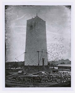
This photograph, taken circa 1876, depicts the construction of the foundation for the Washington Monument in Washington DC. The picture was created by the Federal Works Agency Public Buildings Administration, and is currently included in the Still Picture Records section of the National Archives at College Park. By examining the image, it is evident that the image was taken before the break in construction which occurred from 1854 to 1877, as there are scaffolding and raw materials all around the unfinished monument, as well as men who seem to be working on the top of it. Some greenery and a few buildings are visible in the background, which gives a look into the landscape of DC at the time, which was not nearly as developed and held many more trees than it does now. There is also water visible in the background, though we aren’t told which side of the monument we are shown, so it is difficult to tell if this is the river or an canal that existed at the time. This image gives insight into the layout of DC in the late 1800s, as well as a visual understanding of the construction process of the famed Washington Monument.

map one

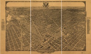
This map, published by the Columbia Planograph Company around 1922, depicts a birds eye view of Washington DC. It is not drawn to scale, and north is meant to be in the top right corner. The capital building can be seen in the center of the map, with the national mall stretching before it and many other, unidentified buildings surrounding it. Despite not being to scale, the map does show the size of DC at the time, as well as the number of buildings and the division of street blocks. Along the side of the map, it does identify important buildings and places of interest, making this map useful for gaining a sense of the size of the city and it’s buildings and monuments. It would also be useful in identifying many of the differences between the city’s current look, and the way it looked years ago.

These sources are essential to understanding Washington DC as it used to exist, as well as its development into the city we now know. The photograph of the Washington Monument was more difficult to analyze than the map, because less space is shown and less visual information is provided, but both show important insight in their own way.